In the last part of the previous article, after photographing the train arrivals and departures at Honna Station, can you stand by to photograph the Tadamigawa 4th Bridge (between Aizu-Mizunuma and Aizu-Nakagawa) within 30 minutes? Would I make it in time?
I thought it would be quite tough, but I managed to make it in time by moving within the safe driving range.
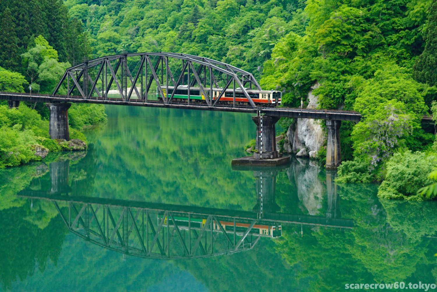
8:50 Tadamigawa 4th Bridge, Aizu-Wakamatsu bound (right direction) 426D
DA50-135mm. It is hard to believe that this is the same 4th bridge that was floating in the river mist the evening before in ink painting (lol). The wind calmed down nicely and I was able to take some beautifully done pictures. Don’t tell me that the picture is a little out of focus.
The picture of oriental ink printing was taken from Mizunuma Bridge yesterday, but the picture of ↑ was taken from the “Photographer stand” in front of the snowshed, a little further toward Aizu-Nakagawa st. This spot was not there when we visited last autumn, so it must have been recently improved.
By the way, here is a photo of GF10 taken at the same stand.
It’s not easy to take pictures with two cameras, but if you get it right, it’s convenient to try both vertical and horizontal compositions in a situation like this. The vertical composition gives a more mountainous landscape with the Tadami River and the train nestled in the bosom of the mountains of Oku-Aizu, which is a good impression.
On the second day, we were up before 5:00 a.m., and moving around here and there, then it was still 9:00 a.m. So I took a 20-minute break at “Oku-Aizu Kaneyama car park” (a small roadside station adjacent to “Miori” which we visited the day before, across the parking lot) .

I had some tea and bought a bottle of “soda water,” a local specialty, as a souvenir, and the 20 minutes passed quickly.
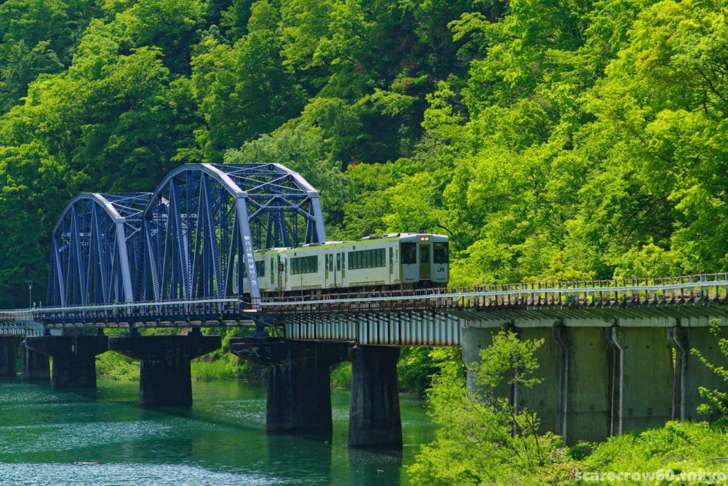
Now, back in action. Next stop was Aizu-Kawaguchi station. I parked the car at Kaneyama Fureai Hiroba where I stopped an hour ago and walked 3 minutes toward Kami-Igsa bridge. I was careful not to disturb the traffic on the bridge as I photographed here the “scene of the train arriving at destination”.
9:40 Aizu-Kawaguchi station, arrival of the train (right direction) 425D
The Tadami River flows right beside the station building and platform, and the area around the station is as bustling as the central part of Kanayama Town, with the town hall and public high school located in close proximity to the station.
Since it is the weekend of the holiday season, a special train will make a round trip between Aizu-Wakamatsu and Tadami later, but there will be no train service for an hour or two until then (if it’s on the regular schedule without special train, there would be a 3-hour gap!) ).
Since it would be a waste to just wait for this blank time, we decided to go to Tagokura Lake and Dam, the birthplace of the Tadami Line’s most scenic section.

I think it took about 50 minutes from Kami-Igusa Bridge to Tagokura Dam, driving slowly on Route 252 by car, enjoying the scenery and locating to take pictures of the train. We arrived at about 10:30 am.
The sky was getting clear, but the clouds over the mountains had not yet lifted, and the light conditions were too harsh to get a good shot of the lake, with the excuse that Lake Tagokura is here.
There is still snow in the valleys of the mountains on the Fukushima-Niigata border, but it is already quite hot down there at this time, and the bikers hanging out by the dam lake looked slightly sick by the heat.
This is the top of a series of large dams. Looking downstream, the view of the dam lake, river, and mountains is quite magnificent. The white stuff at the foot of the dam wall below us could be ice or snow.
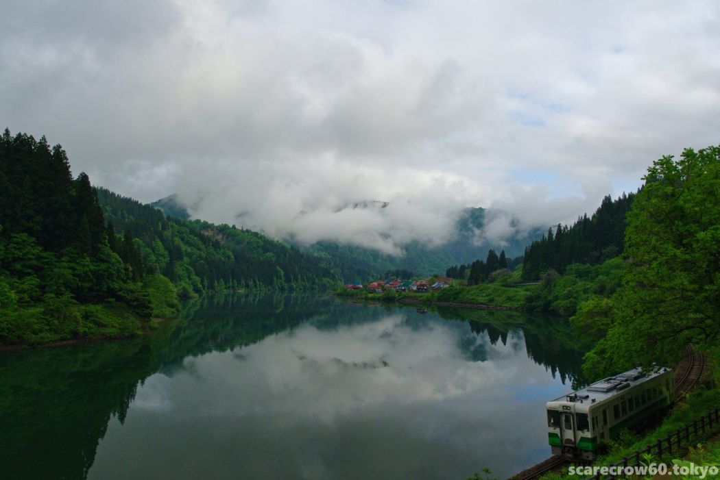
On the way back, Lake Tadami (lake of Tadami Dam) one level below us became a nice water mirror for a moment, so I took this photo.
The dam you see in above photo is the Tagokura Dam, which we were standing on top of earlier and looking at. Can you believe it when I explain that I took this photo looking up in the opposite direction from the dam embankment, which is slightly visible at the far end of the water surface in the another above photo?
What a imbalance of seeing it at this size even though it is extremely far away! How huge the dam is! Even after seeing it on a map, I still could not quite accept it.
After leaving the Dam, the time for the special train was approaching, so I went to Aizu-Gamo station to take pictures of the scenery running at the foot of mount.
It was a smile on my face to see a carp streamer swimming next to the small station house, which had not yet been put away. The steep slope in the background is Mt. Gamo.
A quiet, unmanned station platform. The clouds have lifted a lot and the skies are clearing, and the temperature is getting warmer and warmer.
Trains heading toward Koide/Tadami will cross the Managawa Bridge (between Aizu-Gamo and Tadami) soon after passing Aizu-Gamo station.
12:05 Train bound for Tadami at Managawa Bridge (left direction) 9425D
I was greedy in my composition, wanting to capture the bridge, the railroad crossing beyond it, and the steep slopes of Mt. Gamo, colored with fresh greenery, all in one shot.
Gamo is not a very high mountain at 828m, but it is called the Matterhorn of Aizu (named by the late Junko Tabei, a famous mountaineer) and is a beautiful but steep mountain that is not easy for beginners to climb.
However, it is said that from the top of the mountain, it is possible to take pictures of the great railroad scenery, which is quite spectacular, and it is a fact that many photographers have made the difficult climb with their full equipment and have published their wonderful works. Wow, I can never imitate them.
As usual, this article has become long and verbose. Let’s end this article for now.
Next time, the 2nd day of “A man who takes pictures of the Tadami Line only for 3 days” will continue. Thank you very much,